With a quiver full of electronic maps, apps, and gadgets at your fingertips, choosing the latest hunting tech for scouting can be overwhelming—but it doesn’t have to be. I walk you through the basics of e-scouting before your boots ever hit the ground.
What is E-Scouting and Why Does it Work?
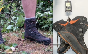
I could see the elk across the ravine. The herd bull was 274 yards away—a makeable shot with my 7mm Rem Mag and a solid rest. First, though, I had to make sure I would be able to get the meat out. Thanks to an app on my phone, I could see from a satellite image that my only option was to hike three miles to the east along an old road, then double back to the bull. The other option was to trespass on a private ranch. Being alone, I made the (regrettable) decision to pass on the shot and ate elk tag soup that season.
I accessed all that intel in the span of just a few minutes thanks to a $30 app on my phone, which showed me property ownership, my location, the bull’s approximate location, roads (open and closed), and the miles I would have needed to pack out that elk. Sure, an old-school topo map would have likely accomplished a similar task, but I made a decision in just a few minutes thanks to satellite imagery and an annual subscription. Aside from a pair of new socks, it was the best money I had spent all season.
Essential E-Scouting Tools and Mapping Layers
In the spring of that same year, an Easter snowstorm had me hunkered in the basement doing the next best thing to hiking—I was scouting from space. I had located that particular elk spot a mere 40 minutes from my home. It had decent access, good security, forage from a nearby alfalfa field, and it just looked “elky.” Using onX Hunt on my home computer, I dropped waypoints at all the promising locations, and it worked. I had everything going for me except an extra back to help me haul out the meat.
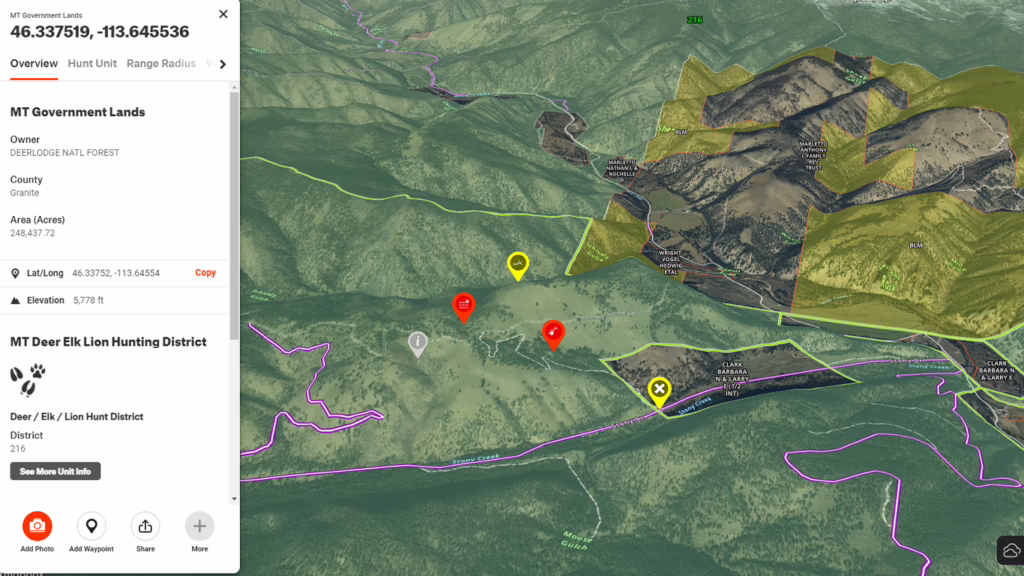
There are dozens of online mapping tools available, and nearly all have one thing in common: layers. You can choose from all sorts of layers that show you recent fires, public/private land, hunting units, forest type; the list goes on forever. Many of these layers pull data directly from government entities like the Bureau of Land Management. The point is you can customize the map to meet your specific needs.
Tool 1: Google Earth Pro and CalTopo for Basic Intel
If you want just the basics, use Google Earth Pro to get aerial and 3D views of any landscape in the U.S. Use it to spot all the basics that animals need: food, water, and security. I hunt primarily in the West, so I’m looking for public land at least a couple of miles from any open road with good forage nearby—like my elk spot. Keep in mind, those satellite images aren’t exactly updated on a regular basis, though. What looks like an open glassing spot might actually be overgrown with young trees because the photo is seven years old. On Google Earth Pro, you can see the year the image was made in the bottom right-hand corner. If you really want to geek out on free maps, check out CalTopo. It will make you drool.
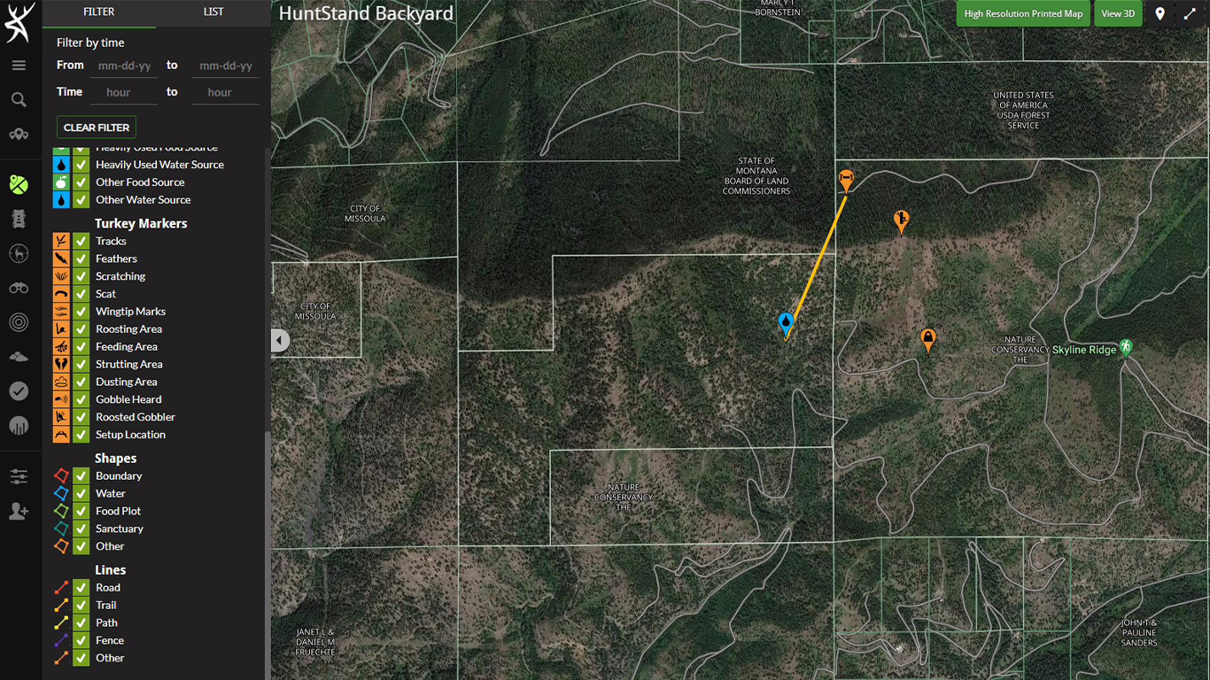
Tool 2: HuntStand Pro Features and Monthly Satellite Updates
If you’re willing to spend around $30 each year, you can get updated satellite images and many other features that take most of the guesswork out of the e-scouting game. With an app like HuntStand Pro ($35), you get access to a freezer full of features.
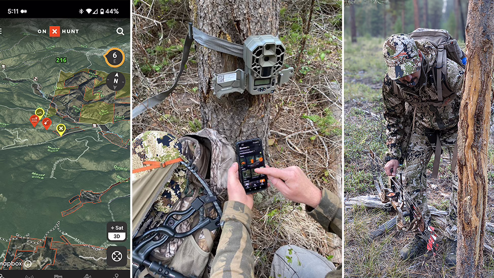
HuntStand Pro provides all the normal mapping and navigation tools, plus a feature called the HuntZone. When you plot your stand or location, HuntZone uses weather data to show you wind direction and speed for the next few days. Plus, you can keep track of all your trail cameras (and photos), share your location with hunting partners, and more. Perhaps even sweeter than the HuntZone feature is that a Pro membership will get you satellite imagery that’s updated monthly.
If hunting the Midwest and eastern half of the country is your thing, then knowing property boundary lines, the location of food plots, and where you hung your stands is a must. Should you arrow a deer and it jumps the fence on a neighboring property, apps will give you property owner information, so you can contact them for permission. If you run trail cameras on your property, the HuntStand app allows you to use AI technology to identify the game species, and it organizes up to 40 GB worth of photos. The options seem limitless, and more features seem to come out with every update.
Ground Truth: Bridging the Gap Between Screen and Boots
All that tech is fun for the basement, but what happens when you pull up to one of your waypoints to hunt? Honestly, the fun part is getting to ground truth all that homework you did in your robe after the kids were asleep. There is no substitute to boots-on-the-ground scouting. The more you scout from home and compare it to the real thing, the better you will get at narrowing down exactly where you want to hunt. If you’re willing to spend a few evenings e-scouting from 30,000 feet, you’ll see your hunting spots in a whole new light.
Top 10 Benefits of E-Scouting for Hunters
- Locate access roads
- Find glassing points
- Create backup plans
- Learn the terrain
- Find those tiny slivers of public land that let you legally access secret spots
- Find water
- Switch between satellite and topo imagery to see the hills
- Mark private land boundaries and see who owns it
- Find burn areas
- Spot forage and food plots